Status: Open |
|
|---|---|
| Site Latitude: N51.606257 | Height ASL Meters: 382m |
| Site Longitude:W003.3057709 | Height ASL Feet: 1263ft |
| Wind Direction: WSW-WNW | Height Top to Bottom Meters: 42m |
| Best Direction: W | Height Top to Bottom Feet: 140ft |
| Minimum BHPA Rating Hang Gliding: Not recommend for HG | Member status: Open Site |
| Minimum BHPA Rating Paragliding: BHPA CP rating | OS Grid Reference and Prefix: ST 096905 |
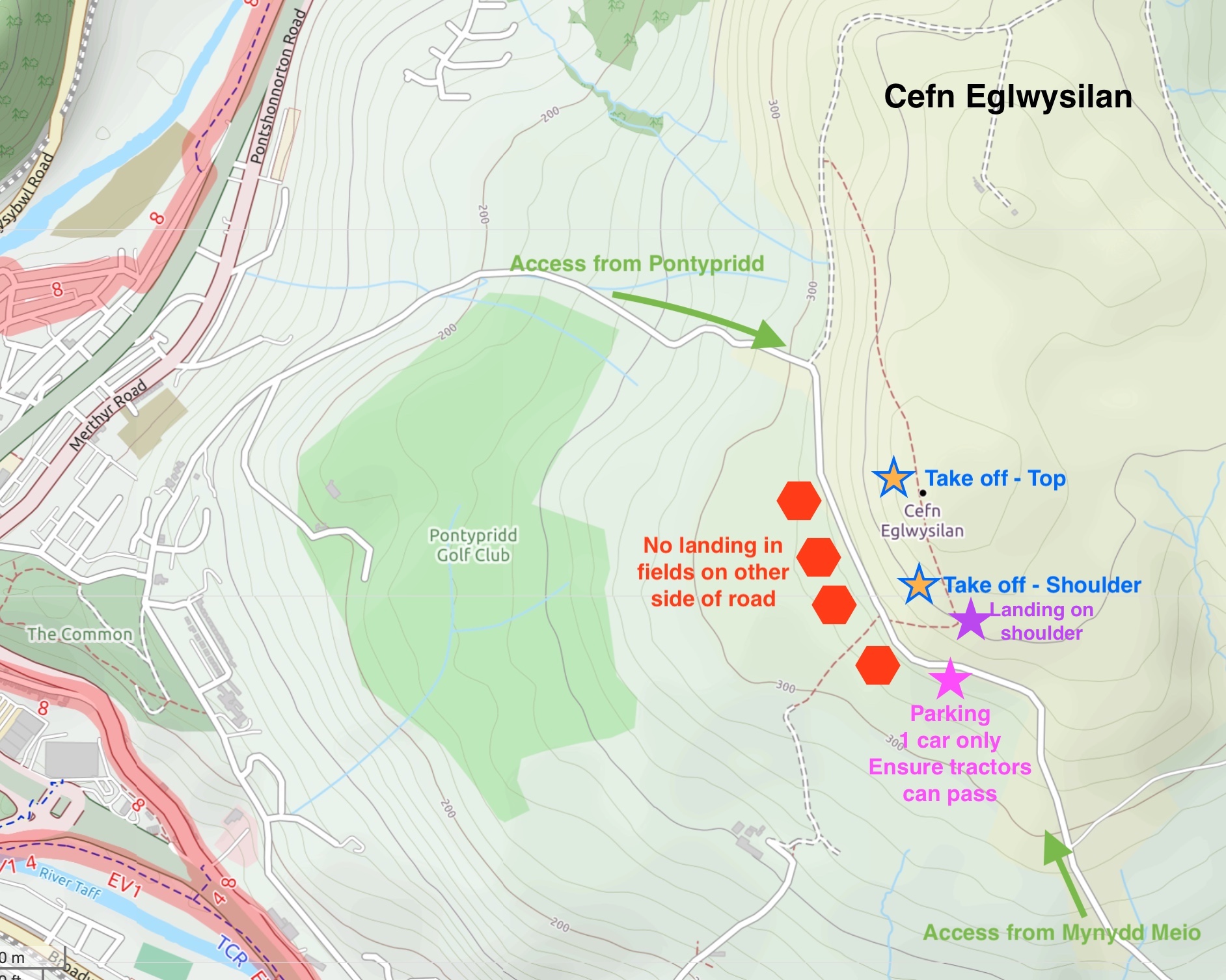
Road access is easiest from the Pontypridd roundabout – follow signs for the golf club and pass it. Alternatively come from the South either via minor roads from the A470 (come off at the Treforest roundabout), or from Mynydd Meio.
One car can park in the lay-by to the south of the site (by the shoulder) allowing for an easy walk up the shoulder to the take-off. Ensure you are NOT obstructing the road – tractors and wide vehiles must pass here too.
Alternatively a lay-by can be found at the foot of the hill as the road runs along the bottom of the hill (immediately west of the top take-off) – ensure cars can still get pass and are not obstructing road access or other gates.
The typical walk up is from the pink parking star on the map to the shoulder take-off.
Latitude: 51.606257
Longitude: -3.305709
Take-off
Access to take-off is by foot only and is easiest if you walk up the shoulder of the hill from the south to the top (typically from the pink star on the map). You can also decide if it’s best to take off on the the shoulder of the hill to the south or the top of the hill (depending on the wind strength). Alternatively walk up the face of the hill and take off from the top but it is steeper.
The shoulder to the south of the main ridge can be good for ground handling.
Landing
The top landing area is large and fairly flat and top landing on or near the summit is an option.
Alternatively paragliders can also land just to the south of the summit on the flattish shoulder (which can also be used for taking off from) which may be a better option especially if you want to pack up before driving home. There is no permission to land in the farmer’s fields out front and landing in these fields must be avoided, especially given that you are in clear view of any traffic passing the hill. Climbing over walls or leaving gates open will also result in a lot of trouble. There is not enough room to fly or safely land a hang glider on this site.
Do not disturb and grazing animals. Especially if new lambs have been settled on the hill.
Be careful of any horse riders, avoid them and do not overfly them.
Top Landing General
South East Wales sites often have very large, undefined take off and top landing areas, which may change position according to conditions. To avoid the potential for collision, pilots making a top landing should keep well away from gliders taking off, who may in some cases have limited visibility.
Flying
Once airborne the small westerly will afford you views over Pontypridd and the Porth valley. The A470 is easily recognised in the valley bottom. Views to the whole coast can be obtained and familiar local hills are easily recognised (such as Garth hill and Craig yr Allt to the south). Immediately to the south you may see paragliders also flying Mynydd Meio (the nearest hill to the left of take-off).
Cefn Eglwysilan is a very small site with a narrow lift band. A significant amount of wind is needed to soar the site (for instance when Merthyr is too windy Cefn Eglwysilan may be flyable). It can probably only accommodate a maximum of three wings even in ideal conditions. It is a good alternative to Mynydd Meio if the wind is more W than SW. If the wind is strong, then wave commonly occurs – coming off the ridges in front which can make for bumpy conditions.

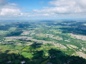
Looking down on the valley towns of Nelson and Treharris just to the north of Cefn Eglwysilan (this photo was taken on an XC from the nearby hill Mynydd Meio).
Hazards
Beware of the road which can be fairly busy and runs at the foot of the hill and do not get too low or you may be boxed in by the road and walls in front of the hill. The A470 valley in front of take-off is full of power lines and pylons, pilots should therefore not attempt to fly to the valley bottom as there are very few landing options.
Beware of turbulence coming off the structures in front of take-off, especially in strong winds. Given the limited capacity of the site you may often be better off going to Merthyr Common if you want to avoid other paragliders and are not completely happy flying with others.
Respect other users of the hill like walkers. Be considerate and do not land in any of the fields.
Open site – This site may be flown by suitably insured visiting hang glider & paraglider pilots.
Not confirmed.

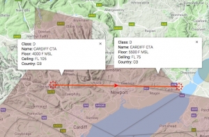
This site is not commonly used for XC, although flights out of the valleys and to the Severn estuary should be possible. Flying across the valleys in thermic winds can understandably put pilots off. Potential can be limited by sea breeze although you can often get away before the sea breeze comes in. The site sits with a 4000 ft airspace limit. When you do get away in a westerly you may be better off cross winding it slightly north if you can to get into the 5500ft airspace before heading downwind in a westerly or you will otherwise be within the 4000ft limit the whole time.
Retrieves from the valleys back to Cardiff are usually straight forward if you can get on the valleys train lines – the nearby stations for this site are Pontypridd or Treforest on the Merthyr line from Cardiff.
Site record
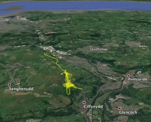
Martin McGahon flew 9.5 km on the last day of 2018 on his Gin Explorer in a WNW wind. He pushed slightly north to Mynydd Eglwysilan before turn downwind and flying to M.Meio.

All rights belong to Google Inc. SEWHGPGC is a nonprofit making organisation.
If you require further advice about a particular SEWHGPGC site please contact a Club Coach. Please report all accidents to The Club Safety & Training Officer Steve Millson and the BHPA. Please visit the BHPA for the most current Incident Report Form.
This document is a guide only.
We advise that anyone Hang Gliding and Paragliding conduct a dynamic risk assessment prior to flying any site. This should be continuously re-assessed due to the changeable conditions of the outdoor environment.
All individuals are advised to take the following into account when making their dynamic risk assessment:
Paragliding and Hang Gliding are dangerous sports that can cause serious injury including bodily harm, paralysis and death. Flying SEW sites is undertaken with the full knowledge that Paragliding and Hang Gliding involves such risks. As the pilot you take exclusive responsibility for all risks associated with your part taking in the sport.
Any liability claims towards the club are excluded.
If you are not sure. DO NOT FLY.
In the Mountains/Rivers/Lakes
Dial 999/112 and ask for the Police and then Mountain Rescue. If you are away from the road side then dial 999/112 and ask for the Police and then Mountain Rescue explaining your circumstances. If you cannot make voice calls, you can now contact the 999 Emergency Services by SMS. NB you must register this prior to an emergency.
In an emergency 999 need to know:
Who is Calling?
Your name and mobile number.
What?
Briefly, what is the problem, including the state of the casualty. Ensure you use the buzzword Fall From Height
and Remote Location.
Where?
Cefn Eglwysilan (next to Mynydd Eglwysilan) – a hill above and to the east of Pontypridd. The nearest road is Eglwysilan Road.

